
(Seen from the Don Barbershop septet while crossing the DAM)
We woke up and had a lovely breakfast at the hotel followed by making delectable sandwiches in the parking lot. Although there were no tomatoes left. Gasp!
We piled into the vans and drove to Wilderness Visitor Adventures guide company which was close by and headed to our 16 mile boat ride through Glen Canyon. Glen Canyon is a total of 197 miles long.
They told us no shenanigans for the trip and we had no shenanigans. We are good folk.
We drove through a long tunnel to get to the dam. Below is a cute photo of the group on the bus to Glen Canyon!


Everyone sees the dam and said: “G-D DAM!!”
The guide talked to us a little about the dam although we were about to learn more later in the day. We learned that the tunnels on the side are the overflow tunnels and the sediment stays in the upper basin. He talked to us about the fear of deadpool (the water dropping so low that the dam can’t create electricity any more). He explained that the water levels are different on different days depending on energy usage. Like Wednesday is a busy work day and Sunday is not. Very cool!
We were given hard hats for the walk to the boats and then piled in.
Off we go on the super dandy boat!

We started in the Navajo Formation. The Navajo Formation has lots of cross bedding from the erg.

Don pointing to the dark staining set, this is the desert varnish. There is iron and magnesium oxide leaking out. There are microbial aspects too!

Selby demonstrating the polarization of the desert varnish with sunglasses, MINERALOGY!
Eventually we started getting to other formations. Wow!

(Navajo and Kayenta contact)

Once upon a time, the river followed a different path. This is visible by the swell pointed out in the image above.

Hackle. This is created because the fracturing is not in one constant motion. There is one induction point. In this case iron oxide is precipitating out and it comes out in one spot.
Aviva: “What is the rule of circles?” Arlo: “Circles exist”

Limestone layer pinching out. This is freshwater lake. Fresh water carbonate.

Reduction Spot. This is where there is no iron oxide. We saw a bunch WHAT!

Vertical normal fault seen on both sides of the river, super high intensity of fractures. Unknown as to why. Maybe someone could study this…

All of this sand dune’s sediment came from above. The wind transportation is right to left. NW to SE. We can tell because the left is more steep and the right has a more gradual slope.
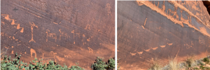
Along our boat ride, we took a stop to view the petroglyphs preserved in the sandstone. The descending sheep petroglyphs are estimated to be 3000-6000 years old. The row of sheep on the bottom(not really visible in image) were recently uncovered when sediment surface levels dropped, bringing people to believe there could be more petroglyphs further down.
Don’t be like Trent! PSA from Maya the arch person: Vandalism is unfortunately really common in archaeology sites both this type and looting. Often sites are kept a secret. Also a site’s status is really important so that it can be protected like this one is now. (Although unfortunately it wasn’t before)
Some students and Selby took a dip in the water at this stop.
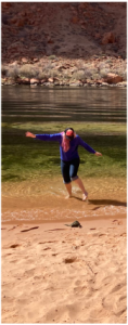
Selby doing the polar plunge… Too cold!

Differentiating the layers:
We began our boat ride only seeing the Navajo Formation Sandstone, but by the end of our trip, 3 more formations became visible in some beautifully dipping beds as you can see in the annotated image above. As described previously, the Navajo sandstone was formed in an eolian environment causing it to show some lovely cross bedding. However, we can see a change in environment when looking at the Kayenta Formation below the Navajo which displays no cross bedding. Below the Kayenta is the Moenave Formation, very similar to the Kayenta however now we move further back in time from rocks Jurassic in age to Triassic. The Moenave Formation is lighter in color from the Kayenta representative of reduced oxidation state. Below the Moenave in the Chinle Formation, seen before at petrified forest, which consists of shale deposited in a fluvial environment.
After a bit of a bus ride with some very classy scenic views that the token awake people got to see we arrived back in Page and headed back to the dam. This is the 4th largest dam in the lower 48. There is the upper basin of the dam and the lower basin of the dam. The Colorado river basin covers 246,000 square miles and provides for about 40 million people and 5.5 million acres of agricultural land.
The upper basin is the inflow of the reservoir this includes the states: Colorado, Utah, and Wyoming
The lower basin is the outflow of the reservoir this includes the states: Arizona (that’s where we are!), Nevada, Southern California, New Mexico, and even though it’s not a part of the US Mexico too.
The dam has 1 million kilowatts of capacity! WOW! There is an emergency storage of 30 megawatts reserves for instant on demand. That would make me go Zoooom.
Now let’s talk DEADPOOL!
(not the movie, this is serious)
They suspect this might happen later this year, so the questions arise: what is it? Where did the water go? and how do we stop it?
Deadpool is when the water is below intake (can not hit the turbines) and it can no longer produce power. At the moment the water is ~20-30 feet from reaching deadpool. The water is 172 feet below full, that is 40% full.
The water is coming from the rocky mountains which are getting more snow now. However, the evapotranspiration processes make it hard for the water to get all the way to the reservoir. 80% of the water is not making it to the reservoir.
There are few options on how to stop this including Arlo’s suggestion of a rain dance. There is taking out the dam which is complicated because of all the sediment in the reservoir and where that goes. There is also a reduction of water use from the upper states. This is currently the ongoing attempted method to try and save the day from deadpool. All of the states currently have a right now plan to reduce and south California has a long term plan. However, hopefully peer pressure and more importantly the FEDERAL GOVERNMENT can help out.
Article on the future of the Colorado River and what can be done:
Colorado Compact 1922
The Colorado compact was put in place with silly little rules: first come first serve. This has dire consequences politically, environmentally, and economically. Basically the people that are the most wasteful get the most rights. Also the Colorado compact completely forgot about the indigenous community, so that ain’t classy (the indigenous community is being included now). All the resources need to be divided by the states and agreed upon by the state governments, like an allowance system that decreases because the water levels are dropping.
This talks about what the Biden-Harris administration is doing. The inflation Reduction Act is investing $4.6 billion
The professors reactions to the whole water situation:
Selby: “We’re doing a bad job”
Don: “Water… dollar signs”
Arlo: “Water should cost more”
Don’t worry they sound optimistic though. 🙂
We ended the day at a lovely Mexican restaurant, thank you for paying Arlo! Some of us pet a dog, some of us went in the hot tub, some of us did both. The dog…. was cute.

Bonus material:
Joke of the day: Don: “Emily looks severe, better than larimide”
Mishearing of the day: “Selby related deaths are on par with car related death” (Selby to selfie)

(Don giving the finger to finger rock)

Lots of love, Maya and Mary Rose<3
One response to ““Oh Mama” What a boat, what a dam! Day 4”
Thank you for your articles. They are very helpful to me. May I ask you a question?