Hello folks! Greetings from the far distant land of Arizona, where we arrived last night after a fortunately uneventful plane ride.
First thing this morning, we packed up and hit the road. Fueled by a lovely continental breakfast from the GreenTree Inn, we set out from Phoenix, generously supplied with snacks, rock hammers, hand lenses, and state-of-the art compasses that Arlo instructed us not to lose. As we were driving out, we saw some mesoproterozoic rocks in the surrounding terrain that according to Arlo were around 1.5-1.7 billion years old. The outcrops around us were breathtaking and certainly a lot more exciting than Pennsylvania (sorry, Pennsylvania).
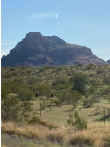
Blurry Proterozoic outcrop from car window (Selby’s car, a.k.a. Flo (Florence) “The Machine”)
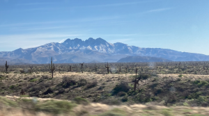
Four Peaks mountains: you can see pendants of darker country rock falling down into granitic plutons (lighter rock) below!
Our first stop was a short introduction to the geology of the region and an opportunity to see the magnificent saguaro cactuses up close. As we stood on a hill and tried not to get poked by cacti, Arlo gave us an overview of the geology in the region. To the north of us was the Colorado Plateau and to the south of us was the Basin and Range; we were standing in the Transition Zone (creatively named because it is the transition from the plateau to the Basin and Range). We were standing on rounded granite boulders (perhaps fluvially eroded) as we discussed the history of the region and collected some beautiful jasper samples (although we already had a Jasper).
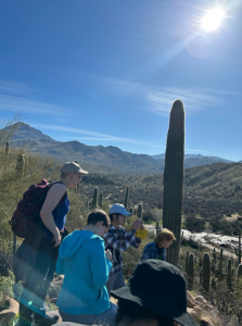
Students taking in the view and enjoying the cacti.
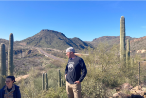
Arlo standing amid cacti looking slightly put out. Perhaps we’re climbing the hill too slowly.
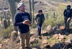
Arlo cradling his rock baby.
Our next stop was the Barnhardt Canyon Trail, which we were pleased to discover was not snowed over. This trail allowed us to follow the geologic history of the Mazatzal Group, which the few other hikers on the trail were not quite as interested in hearing about as we were. Basically, a very long time ago (more than 1.7 billion years), subduction began under oceanic crust and produced a mafic melt that partially melted the oceanic crust above. This partial melting produced increasingly felsic melts over time (since quartz/feldspar/felsic material melts at the lowest temperatures), and gradually built up a volcanic arc. This arc was eroded and siliciclastic sediments were deposited into a basin, forming the Mazatzal Group. Then, subduction on the edge of the then-North American continent brought the Mazatzal Group towards North America, closing the intervening ocean basin and smushing the two together in the Mazatzal Orogeny around 1.7 billion years ago. This process formed the Mazatzal Mountains atop which we were standing. It should be noted that the Mazatzal Group was not a pioneer in this area; the Mojave and Yavapai arcs beat it to the punch, with the Mojave arc accreting onto North America around 2 billion years ago.
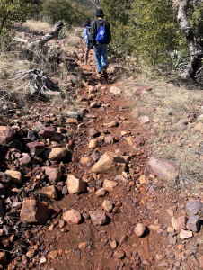
Starting out along the Barnhardt Canyon Trail! The beginning felt a bit like wading up a very shallow creek. Apparently the soil around here is not really used to absorbing this strange thing called precipitation.
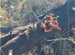
A cool fungus! Because fungi are also worthy of notice in addition to rocks.

A rushing stream flowing down into the gully below. Probably due to all the snowmelt.
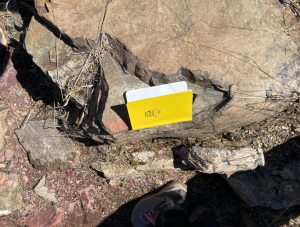
As we hiked along the somewhat wet and snowy trail (unusually wet considering we’re in the desert), admiring the various juniper plants and prickly pear cacti and agave plants (fun fact — shoutout to Maya — apparently they only put out flowers when they’re dying?), the first outcrop we saw was an ophiolite — the Payson Ophiolite, to be specific, which forms the base of the more than 1.7 billion year old Tonto Group that stretches from the Mogollon Rim to Phoenix. The ophiolites — bits of oceanic lithosphere accreted onto the continent — were evidence of the aforementioned subduction/closing of the ocean basin when the Mazatzal Group accreted onto the continent. Apparently there are pillow basalts and sheeted dikes in the Payson Ophiolite to prove that it is indeed an ophiolite, but we didn’t get to see any, so I suppose we’ll just have to take Arlo’s word on this one. The Mazatzal Group sits unconformably on the ophiolite. It doesn’t look all that impressive in the photo but trust us, it’s important.
The rather unimpressive but important ophiolite.
As it turns out, the Mazatzal group has some really amazing folds (in the Maverick Shale — more on that later). These folds resulted from the deformation of both weaker and stronger/coarser material (probably turbidites, according to Don?) which meant that some of the folds had a smaller wavelength and other, more resistant, layers had a larger wavelength. You could also see some thrust faults (as indicated in the photo below) where the fold kind of crunches up on itself. The folds have axial planes that dip to the right which indicates that the material was being pushed to the left. We ate lunch staring at the absolutely fantastic view below and attempting rather unsuccessfully to draw the folds. The sandwiches were absolutely first-rate, thank you for asking. Shoutout to the random guy who asked what level our geology class was, heard “undergraduate,” and then decided he’d heard enough and walked off.
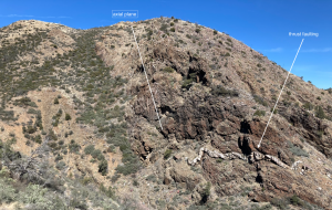
Our lunch view. One arrow is pointing to thrust faulting and the white line on the left indicates the right/eastward-dipping axial plane.
The hinge of a fold, measured to have a strike of 95 degrees and a dip of 38 degrees if my phone is to be trusted.

Arlo pointing out structural features.
Here are some closer-up images of the folds!

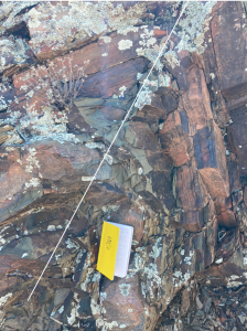
This image shows tectonic cleavage parallel to the axial plane of the fold (outlined with the green), which probably formed due to pressure solution (minerals dissolved into fluid because of external stress and left behind phyllosilicates preferentially that were oriented along the axial plane).
Here’s another very cool fold with the fold axis outlined in white!
This is the hinge of a fold with mineralized veins (either calcite or quartz) forming due to the tension generated by folding.
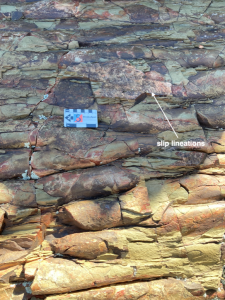
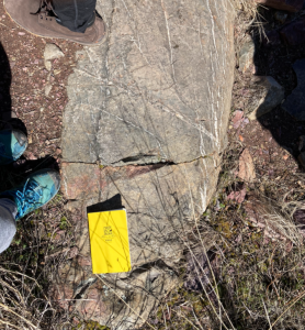
This image shows some mullions, which are a fold structure that forms when a weak bed is surrounded by stronger beds — resulting in a sort of heart-shaped “anti-fold” structure. You can also see slip surfaces down the dip of the fold which indicate flexural accommodation as the different layers of the fold slide over each other. Classic geology textbook image.
Within the Mazatzal Group itself, there is some interesting stratigraphy that we were fortunate enough to witness in action. The oldest layer of the Mazatzal Group (around 1.7 billion years old) is the somewhat ominously named Deadman Quartzite, which formed in a near-shore environment. There’s got to be a story behind the name, but we didn’t think to ask. On top of the quartzite is the Maverick Shale, which formed further out into the ocean/in a deeper basin; this is where all the folding occurred. On top of that is the Mazatzal Peak Quartzite, and then finally the Hopi Spring Shale, which has been dated to be around 1570 Mya (this is confusing because that’s younger than the Mazatzal Orogeny but the shale is still deformed by the orogeny. Another mystery for a future crop of geologists!). All of these rocks are metasedimentary rocks that underwent moderate deformation during the Mazatzal Orogeny.
Perplexingly, as we stood on the Maverick Shale, we could see the Dead Man Quartzite in the far peak above us. “But wait!” you cry. “Shouldn’t the Dead Man Quartzite be below the shale if it’s older?” Ah yes, reader, what an astute observation. Turns out there’s a thrust fault (pictured below) that transported the quartzite up and over the footwall upon which we were standing. Tectonics in action — pretty cool. 🙂

Mazatzal Peak Quartzite
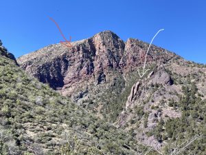
The white arrow is pointing to the thrust fault and the red arrow is pointing to the Deadman Quartzite.
Our next stop took us to the side of the road, where we wore hi-vis vests for safety (and reassured local law enforcement that we were all fine and there for perfectly normal geology reasons).
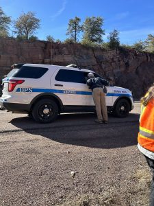
Arlo leaning in to talk to the police. (Everything was fine.)
There, we got to examine up close the Great Unconformity, a boundary between the 1.7 billion year old Proterozoic Payson Granite and ~500 million year old Cambrian Tapeats Sandstone. The granite was extremely friable (crumbly) and has clearly felt the effects of its incredible age. The sandstone, in contrast, is much more resistant to erosion and shows much fewer signs of weathering. The unconformity between these two units is a nonconformity – with the younger sedimentary rock unit sitting above a crystalline (in this case, igneous) unit.
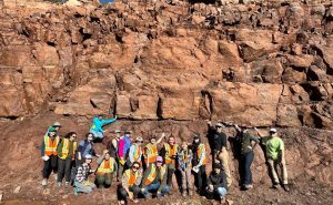
Group photo at the great unconformity, with everyone standing in front of the reddish-brown granite and below the lighter tan sandstone.
The gap between these two rock units represents 1.2 billion years of missing time: was no rock deposited throughout that whole period? Or, was rock deposited but then removed by erosive processes? Clearly, a major geologic change occurred to allow this gap and then the deposition of these sedimentary rocks. Arlo explained that the breakup of Rodinia formed new passive margins along the edges of the North American craton, where water began inundating the land in a global phenomenon of Cambrian transgression. The transition of grain size from pebbles to sand in the Tapeats Sandstone indicates that the basin was getting deeper during this time, corroborating this narrative. As the sea levels rose, sediments filled this basin, forming the rock which we see today.
Payson Granite boulders!
Since the snow prevented us from visiting the Mogollon Rim Visitor Center, our final stop brought us to a delightful geologists’ playground of huge, round boulders of Payson Granite. These granites were altered through two main processes. First, joints formed in systematic orientations across these rocks. The joints could have formed during the contraction of the rock when it cooled, or more likely, from the release of stress when the rocks came up to the surface and were no longer experiencing pressure from overlying rock units (as Arlo has told us in structural many times, the joints would form in the direction of minimum principal stress). Then, a combination of freezing and thawing ate away at the edges of these joints in a spheroidal erosion process, rounding them out into the fun shape they hold today. They are called inselbergs, meaning “island mountain” in the original German.
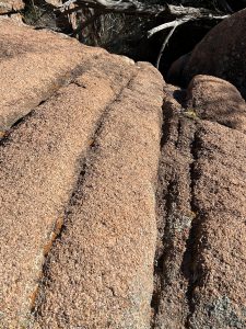
A close up of an inselberg, showing the joints running across the rock.
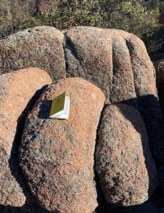
A slightly less close-up view of an inselberg and its joints.

An image of grus (no, not the Despicable Me ones), everyone’s new favorite gravel. They’re formed from weathering of quartz and feldspar crystals off of granite in arid environments.

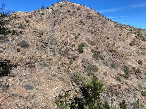
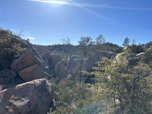
Inselberg formations in the distance.

View of the Mogollon Rim from the Barnhardt trail, visible as a white band in the background. The rim marks the edge of the Colorado Plateau.
Bonus: Got some delicious Mexican food for dinner today. Arlo had another small interaction with the police but again, everything is fine. NO need to worry.
That’s all for day one! Stay tuned for more hikes, great views, and incredible rock forms.
~Elena and Jasper
[Arlo police interaction count: 2]
Bad geology joke of the day:
Why didn’t the Maverick Shale want to buy a lottery ticket?
A: It didn’t need to; it already had mullions.